Three Day Bikepacking Trip from the Hub of Humanity
Thanks to Mike W. for asking for a more detailed description of the three day trip referenced in the Peck Forest to Wheelerville connection from Adk Sports, Bicycling, April 2019. I don't have a GPX file of the route that Bob and I followed for our 2017 trip but here it is with variations. Back in Spring 2017 my buddy Bob and I set off on a route I had mapped out and most of which I had ridden in sections over the years of exploring the southern Adirondacks on mountain bike.
Break out your Nat Geo Adirondack Map (#744)
We left Benson fashionably late as has been our preferred mode of departure over the years. We headed up through the Benson Trails and came out on a dirt road that took us to Hamilton County Route 6, aka the Benson Road.
Once on the Benson Road, or if you're still on the Benson Road, continue into Bleecker and it becomes Fulton County Route 125. Cruise on out for about four miles and look for your first left, the Barlow Road. It'll lead right into a climb, and then after a brief downhill will 'T'. Hang a right, staying on Barlow Road. Continue onto Fulton County Route 145 and in Bleecker Center make a right onto Holmes Road.
Our plan was to head up to Peter's Corners and continue into Holmes Lake and Irving Pond and out to FC Route 112. From there head east and then south on Hohler Road, Fisher Road, cross NYS 29A and continue on south on FC route 137. We made a right on Mussey Road and then a left to head south on NYS 10 a short distance to Glasgow Road. If you were to begin in Peck Forest, head west on the North Bush Road to NYS 10 and then north to Glasgow Road.
Glasgow Road ends at the yellow DEC gate and then it's a rocky climb out of the valley Trail #122 (reference Nat Geo Map 744). Continue onto Hillabrandt Vly and Trail #124. Trail #124 has some wet swampy areas, so be prepared. At the next trail intersection, left will take you to Mud Lake, continue straight onto Trail #123. Note from the map there are two bail out routes, not numbered, that will take you to RT 119. The first, at Glasgow Mills is very rideable. The second at Mud Lake is not good.
Continue to Stewart Landing. There is good, albeit popular on weekends, camping at Stewart Landing. Head west on Stewart Landing Road, paved, and then make a left onto Bliss Road, unpaved. Cross over RT 119. On the map there is a triangle with the left side angled to a road that will take you to Middle Sprite. In reality there is no triangle; head straight across 119 and continue on the dirt road.
In about two miles there is a left, but from this direction of travel it will appear to be someone's driveway. It is, but a sharper left reveals an old jeep road that leads down to Sprite Creek and "Wildchild" Falls. Much paddling carnage has occurred at Wildchild. Please respect the private and posted property. Continue across the creek on the snowmobile bridge and climb out of the valley. At the "T" make a right on Irish Settlement Road. There is a small swath of Ferris Lake Wild Forest here and it's the only State land since leaving Trail #123 and until Oregon on the Piseco Powley Road.
Time wasn't on our side so we boogied down to Lotville Road and headed west to Voorhees Road and North. This area warrants some exploring and it would be interesting to connect to the Sprite Creek lower take out on Youker Road.
When Voorhees Road T's with Route 119, make a left and then a right on Route 104 in Emmonsburg. There is now a store in Stratford for resupply. Continue through Stratford headed North to the Piseco Powley Road. Once across East Canada Creek in Oregon there are plenty of camping spots and plenty to explore as well: "Potholers" and Goldmine Stream Falls are two places.
Once out to NYS 10 we headed north to NYS 8 and back East to Speculator. In Speculator we continued onto Elm Lake Road and picked up the Adirondack Trail Ride Route headed south.
https://theadirondacktrailride.com/route/
There are multiple variations to cut out some of the more challenging TATR route (Girard's Sugar Bush to Pumpkin Hollow). In Lake Pleasant leave RT 8 and ride the south shore around Lake Pleasant and then hang a right south on Gilmantown Road into the village of Wells. There is a state campground just south of town. Continuing south on RT30 make a left onto the Pumpkin Hollow Road and ride up to the Murphy Lake Trailhead. Heading south to Murphy, Middle and Bennett Lake is an 8 mile technical ride that brings you out onto Creek Road in Hope Falls. Right is a climb up and over to RT30. Left is a valley ride along East Stoney Creek to a "T" with Old RT30, with a left there leading to the village of Northville.
Break out the maps and download the TATR GPX file to a phone or GPS unit and have fun exploring!
 |
| Climbing up Glasgow Road |
 |
| Hillabrandt Vly |
 |
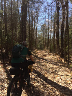
| Bob, not widening the trail. |
 |
| Near "Wildchild" Falls, Sprite Creek |
 |
| #124 |
 |
| Top of the "Potholers" East Cannada Creek |
 |
| Glasgow Trail |
 |
| Where Glasgow Climb gets "technical." |
 |
| The Long Level on TATR route. |


Comments
Post a Comment